OUR SITE DUE DILIGENCE REPORT
SEPTEMBER 23, 2020
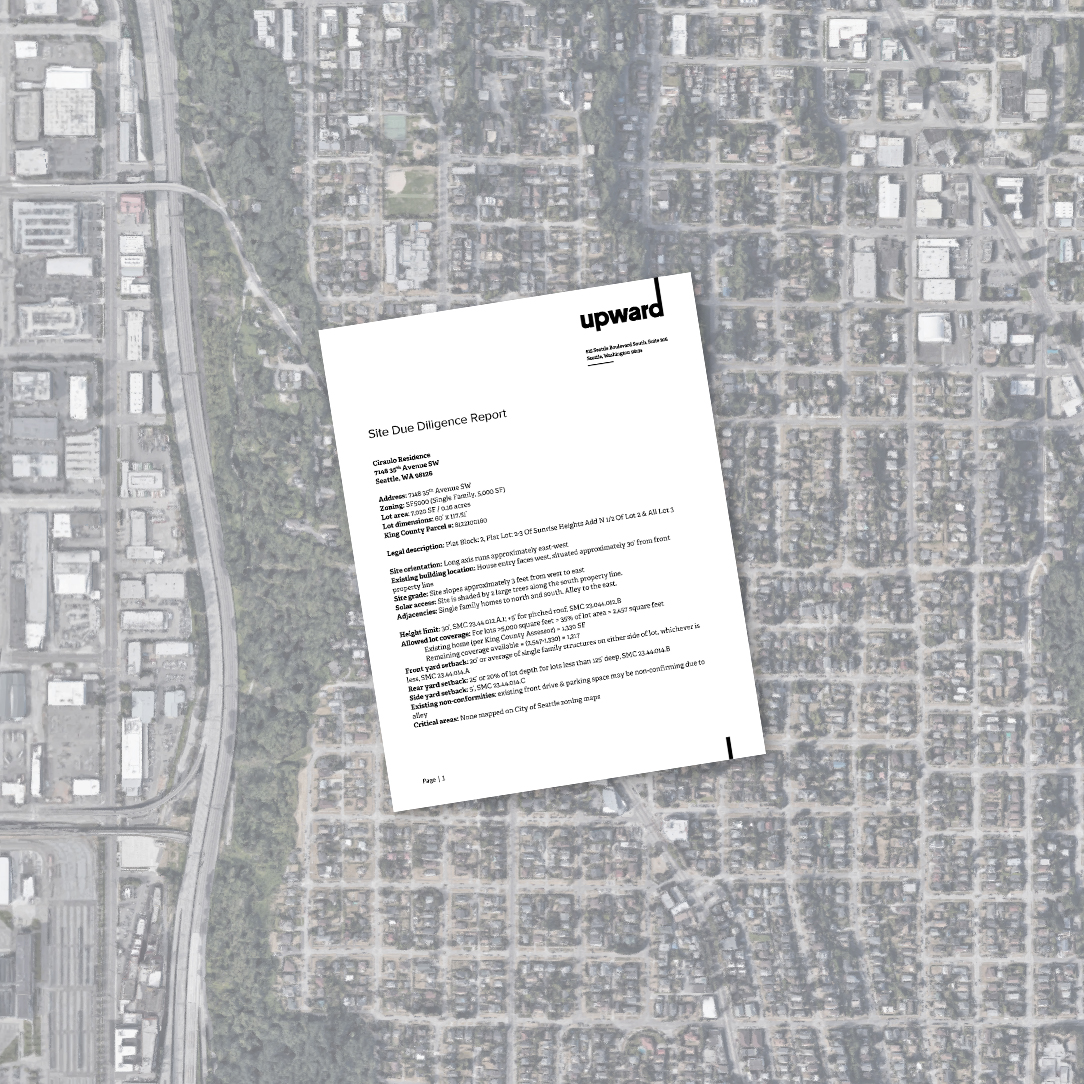
REVIEWING THE SITE
When starting any project, it’s important to have a complete understanding of the condition and characteristics of any property. As a company, we’ve developed a document called our Site Due Diligence Report, which enables us to follow a quick review process to ensure all our projects are feasible. Regardless of the project type, the due diligence report helps us organize all the information that the city and county provide for properties and existing structures. Below we will review the portions of this quick report, and help you understand what each section means and why it’s important.
THE CATEGORIES
Below is a list of all the elements we include in our Site Due Diligence Report. For all projects, we source our information from a variety of different places including county departments of assessments, city parcel data, GIS maps, and city codes.
-
PROPERTY ADDRESS
-
PARCEL NUMBER
-
LEGAL DESCRIPTION
-
ZONING
-
LOT AREA (SQ FT)
-
LOT DIMENSIONS (FT)
-
SITE ORIENTATION
-
EXISTING STRUCTURE(S) LOCATION(S)
-
EXISTING PROPERTY ADJACENCIES
-
EXISTING NON-CONFORMITIES
-
SITE GRADE
-
SOLAR ACCESS
-
HEIGHT LIMIT
-
ALLOWED LOT COVERAGE
-
ALLOWED FLOOR AREA RATIO (FAR)
-
FRONT YARD SETBACK
-
REAR YARD SETBACK
-
SIDE YARD SETBACK
-
ECA
PROPERTY ADDRESS
We start our document off by writing down any and all addresses associated with the project property. (For the purpose of this post, we will use our office location for all example elements, Eg. 815 Seattle Blvd S 98134)
PARCEL NUMBER
The assessor’s parcel number (or APN) is a number assigned to properties by the local taxing authority. They serve to uniquely identify the subdivision of land that we call property. Identifying the parcel number when talking about a property is the most reliable way to describe that particular area of land, and is required for tax purposes, titles, deeds, and submitting construction permits to the city. (Eg. Our office parcel number is 766980-0045) The Parcel number can be found through the King County Department of Assessments, or through the SDCI Parcel Data.
LEGAL DESCRIPTION
The legal description is a written record which provides legal evidence of the boundaries and allows surveyors to accurately determine property lines. (Eg. Our office property legal description is SEATTLE TIDE LDS REPLAT BLK 283 PCL “A” SEATTLE LBA# 3027113-LU REC# 20181116900029 SD LBA LOCATED IN LOTS 11-16 OF BLK 283 OF SD PLAT) The Legal Description can be found through the King County Department of Assessments.
ZONING
Zoning laws regulate the development and use of land. Typically, you’ll find zoning for residential, commercial, industrial, recreational, agricultural, and mixed-use, but there is likely more detailed zones listed in your city or county. In addition to regulating the use of land, zoning allows the city to set standards for housing density and types, lot coverage, height limits, setbacks, parking quantities, tree and planting preservation, and more. (Eg. Our office is zoned as IDM 165/85-170 – International District Mixed upper-level development) Zoning can be found on the SDCI GIS map, with the zoning layer checked.
LOT AREA (SQUARE FEET)
For the lot area, we are looking for the total area within the property lines. This includes all yards, buildings, decks, etc. (Eg. 48,345 square feet, or 5371.67 square yards) This information can be found through the King County Department of Assessments or the SDCI Parcel Data.
LOT DIMENSIONS (FEET)
There’s a few different ways that we obtain lot dimensions for our projects. During the pre-design phase, we source the lot dimensions online, usually through the City of Seattle Zoning Map Books. This method can be meticulous not the most accurate, however it does provide us with an initial idea of lot size and context to begin. Eventually, we’ll receive a survey with accurate lot dimensions which we will then update in our report. (Eg. 277.03 feet by 150.11 feet)
SITE ORIENTATION
The site orientation refers to which direction the long axis runs according to cardinal directions. We use this description for internal use. (Eg. Long axis runs approximately Northwest – Southeast.)
EXISTING ADJACENCIES
The existing adjacencies on a site refers to any streets, buildings, landmarks, large plantings or trees, etc. that exist in areas surrounding the property. Similar to site orientation, this description is mainly for internal use. (Eg. Seattle Blvd South street access along the entire Northeast edge of the property/building, and gated parking access along the entire Southwest edge of the property/building.)
EXISTING STRUCTURE(S) LOCATION(S)
The existing structure(s) location(s) refer to where any existing structures live on the site, and their orientation according to cardinal direction. The due diligence report is typically done during pre-design, so without a survey the location(s) of existing structure(s) is not precise. (Eg. Existing Building is centered, and aligned with the edge of Seattle Blvd South. There are alley sized spaces on both sides of the building to access gated parking on Southwest edge.)
EXISTING NON-CONFORMITIES
Existing non-conformities refer to parcels, land uses, buildings, structures, or any situations on the property that do not conform with existing zoning regulations. Often times setbacks are the culprits of anything living in this category. (Eg. None)
SITE GRADE
In this section, we call out any existing site slope. There are a variety of different ways we can find this information. First being a simple site visit to determine any existing slope. For a more accurate number, we go to the SDCI GIS map and turn on the contour lines layer. Typically you’ll be able to see a 2′ contour line depiction, and although it’s not very precise, it helps us in the initial phase of a project. Eventually, we’ll recieve a survey with accurate and precise topography lines which we will update in our report. (Eg. Site slopes parallel to the long-axis of the property [running approximately Northwest – Southeast.] The high side being by Seattle Blvd South at 44′, and the low side at 28′, with a total grade change of 16′)
SOLAR ACCESS
Solar access refers to the amount of light that touches the property. Here, we typically either note that the solar access is unobstructed, semi-obstructed due to trees, or completely obstructed due to surrounding buildings. (Eg. 815 Seattle Blvd South Site is unobstructed)
HEIGHT LIMIT
Height limit refers to how tall any structure on a property can be based on city zoning laws. Using the previously found zoning, we search on the Seattle Building Code (SBC) site for the applicable height limit set by the city. (Eg. Height limit is 85′ [except in certain circumstances])
FLOOR AREA RATIO (FAR) | Non-Residential Zones
The Floor Area Ratio (FAR) compares the total amount of usable floor area that a building has, and the total area of the property parcel. This includes the total area of all above-ground floors added up together. Typically, the higher the ratio indicates dense construction. This number helps the city regulate how large buildings can be according to their property size. All existing structures constructed are “grand-fathered” in, and are not required to comply with the FAR ratio set in place; however, any new structures on the property must meet the provided FAR.
Floor Area Ratio = Total Building Floor Area / Gross Lot Area
(Eg. For IDM 165/85-170 [International District Mixed-use] Base FAR is 3, and Max FAR is 7) The Base and Max FAR numbers provided by the city based on zoning can be found on the Seattle Building Code (SBC.) Most residential uses are not subjected to a FAR limit, see Allowed Lot Coverage instead.
ALLOWED LOT COVERAGE | Residential Zones
Allowed Lot Coverage compares the footprint(s) of any buildings or structures on the site, and the total area of the property parcel. This includes structures like garages, swimming pools, sheds, and any nonconforming buildings on the property. Calculating the allowed lot coverage is an easy way to determine the ratio between developed and undeveloped space.
Current Lot Coverage % = [Total Lot Coverage / Lot Size] x 100
The Allowed Lot Coverage is based on zoning can be found on the Seattle Building Code (SBC.) Most NON-residential uses are not subjected to Allowed Lot Coverage limits, see FAR limits instead.
FRONT YARD SETBACK
A Setback is a designated space from the property line inward in which no structures may be located. The front yard is determined by identifying the property line which gains primary access to the property. When a property is located on a corner lot, it’s typical that both edges adjacent to the public streets are required a front yard setback.
REAR YARD SETBACK
A rear yard setback is another space designated from the property line inward in which no structures may be located. The back yard is determined by identifying the property line furthest away from the front yard.
SIDE YARD SETBACK
Side yard setbacks are typically smaller than both front and rear yard setbacks. Again, no structures may be located in these spaces. The side yard is established by the side property lines that extend between the front and rear yards.
ECA
ECAs, or Environmentally Critical Areas, refers to city or state designated areas that provide critical environmental functions. ECA codes address lands and have particular challenges when it comes to development, due to geologic or other natural conditions. Some examples of critical areas are:
- Geologic Hazard Areas
- Landslide Prone Areas
- Liquefaction Prone Areas
- Peat-Settlement Prone Areas
- Seismic Hazard Areas
- Steep Slope Erosion Hazard Areas
- Volcanic Hazard Areas
- Flood Prone Areas
- Abandoned Landfills
- Wetlands
- Fish and Wildlife Habitat Conservation Areas
- Riparian Watercourses
- Priority Habitats for Fish and Wildlife
- Corridors Connecting Habitats
SDCI PUBLIC RESOURCE CENTER
Typically, when we complete our due diligence report, we check to see if there’s any archived records associated with the property. Sometimes, cities have online archives which have public documents associated with construction and permit materials. More commonly, cities will have public resource centers that allow access to publications, information on permits, and other historical records. The local downtown SDCI Public Resource Center stores permit records from 1894 to 2004 in their public Microfilm Library. This is a great resource for anyone looking for original architectural, structural and master plans for buildings.
CURIOUS ABOUT YOUR PROPERTY?
Reach out to us! We’d be happy to talk about how to find information relating to your property.
RECENT POSTS / VIEW ALL POSTS
Recent Posts / View All Posts